Site C is BC Hydro’s last-generation hydroelectric project in the Peace Region of northeast British Columbia, with its main construction phase winding toward completion. Even as Site C commissions, the Peace Region remains a high-demand construction-travel corridor — driven by transmission, hydrogen, clean-energy, and LNG-adjacent work. This guide covers the airport options for Peace Region crews (YXJ, YDQ, YQU), the realistic drive times to site, the rotation patterns that work in northeast BC, and what the post-Site C travel picture looks like. If you are planning crew rotations into the region, this is the planning baseline.
Where exactly is Site C, and why does that shape crew travel?
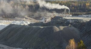
The Site C Clean Energy Project is on the Peace River, about 7 kilometres southwest of Fort St. John and roughly 80 kilometres northwest of Dawson Creek. It sits within Treaty 8 territory and in a region that has supported major civil and energy construction for decades. The geography matters for travel planning because the nearest commercial airport — North Peace Regional Airport (YXJ) at Fort St. John — is 25 to 35 minutes from the dam site by road, while the next-closest options are meaningfully further away.
The Peace Region’s transportation infrastructure is sparse by southern BC standards. Highway 97 is the main north-south artery, Highway 29 follows the Peace River corridor, and winter driving from November through March requires serious planning. Nearly every crew travel lane into northeast BC depends on air service into YXJ or a regional alternative.
Which airports actually serve Peace Region construction crews?
Three airports matter for Peace Region crew rotations. North Peace Regional Airport (YXJ) in Fort St. John is closest to Site C and the primary option. Dawson Creek Airport (YDQ) serves the southern Peace Region and the South Peace. Grande Prairie Airport (YQU) sits across the Alberta border and is often the best-connected option for crews originating in central Alberta or Calgary.
YXJ is served by Air Canada and WestJet regional connections, primarily through Vancouver (YVR) and Calgary (YYC). YDQ has thinner scheduled service — Central Mountain Air and Pacific Coastal have operated the route historically; verify current service at booking. YQU has Calgary and Edmonton connections and frequently shorter total transit times from those origins than a Vancouver routing would provide.
Fort St. John (YXJ) vs. Dawson Creek (YDQ) vs. Grande Prairie (YQU) — which makes more sense?
The right answer depends on where the crew originates and what the project site is. YXJ is almost always correct for Site C and for projects in the North Peace. It is the closest airport to the dam and has the most scheduled service. YDQ makes sense only for crews originating in Vancouver or the Lower Mainland who need to reach the southern Peace or the Tumbler Ridge corridor and want a shorter drive from their airport of arrival.
YQU is the quiet winner for crews originating in central and southern Alberta. For a Calgary-based crew heading to Site C, YQU via Grande Prairie often beats YYC-YVR-YXJ on total door-to-site time. Travel programmes that default to “YXJ because it’s closest” sometimes miss a 2-hour time saving available through YQU and a 2-hour drive.
Driving from YXJ or YDQ to site — what should you plan for?
> From YXJ to Site C, plan 25 to 35 minutes in normal conditions and 45 to 75 minutes in winter.
> From YXJ to Fort St. John hotel properties, plan 10 to 15 minutes.
> From YDQ to Site C via Highway 29, plan 90 to 110 minutes. From YQU (Grande Prairie) to Site C via Highway 2 and Highway 97, plan 2 hours 20 minutes to 2 hours 45 minutes in summer and materially more in winter.
Check DriveBC for current road conditions during the winter planning window. Highway 97 and Highway 29 both close occasionally for winter weather events. The practical planning rule is to add a two-hour arrival buffer to any Peace Region ground leg between mid-November and late March and to treat closures as a normal cost of operating, not an exception.
How do rotation schedules typically run on Peace Region civil projects?
Peace Region civil projects have used a mix of rotation patterns depending on trade, employer, and project phase. Common patterns include 14 days on / 14 days off, 20 days on / 10 days off, and 7 on / 7 off for some support and maintenance trades. Site C specifically has run camp-based rotations for a substantial share of its workforce, with Fort St. John hotels absorbing overflow and non-camp contractors. Programmes managing overflow stays across multiple rotations benefit from a consolidated points strategy — Worldgo’s review of the best hotel loyalty programmes is a useful reference for block-booking policy.
For travel planners, the relevant implication is that rotation-day volume at YXJ is concentrated — Peace Region rotations tend to shift crews in and out on specific weekdays, so Wednesday or Thursday rotation days frequently see airport-level capacity constraints that midweek non-rotation days do not. Book seat inventory in line with the project’s actual rotation calendar, not a generic weekday assumption. On the finance side, rotation travel treatment for expense and deductibility questions — relevant for contractors running their own T&E — is covered in Worldgo’s guide on travel expenses as deductible.
What do post-Site C BC Hydro and clean-energy projects look like for crew travel?
Even as Site C’s main civil construction phase winds down, the Peace Region’s construction-travel demand is not disappearing. BC Hydro’s transmission expansion, hydrogen project development in northeast BC, LNG-adjacent work tied to Coastal GasLink and downstream processing, and ongoing conventional resource work all sustain crew volume into the YXJ catchment. The Government of British Columbia’s major projects inventory tracks active and announced work that drives this forward pipeline, and the BC Construction Association publishes workforce and industry context that matters for how contractors structure rotation programmes across overlapping jobs.
The mix shifts from “massive single project” to “multiple overlapping medium projects,” which is actually harder for travel planning in some ways — coordination across employers becomes the binding constraint. Programmes that are built around Site C’s specific rotation cadence will need to re-architect for more varied demand profiles. That usually means tighter relationships with YXJ-based ground transport, more flexibility in camp-vs-commercial lodging sourcing, and a TMC with active Peace Region knowledge.
Planning a Peace Region construction travel programme? Worldgo can build it around the region’s specific constraints — YXJ capacity cycles, winter route risk, and the evolving post-Site C project mix. Talk to a specialist.
Frequently Asked Questions:
Which airport is closest to the Site C dam construction site?
North Peace Regional Airport (YXJ) in Fort St. John — about 25 to 35 minutes by road from Site C. It is served by Air Canada and WestJet regional connections, primarily through Vancouver (YVR) and Calgary (YYC).
How long is the drive from Fort St. John to Site C?
From YXJ airport, plan 25 to 35 minutes in normal conditions and 45 to 75 minutes in winter. From downtown Fort St. John hotels, plan 15 to 25 minutes. Winter conditions between mid-November and late March frequently extend drive times and occasionally close Highway 29.
What is the difference between Fort St. John (YXJ) and Dawson Creek (YDQ) for crew travel?
YXJ is closer to Site C and has deeper scheduled service through Vancouver and Calgary. YDQ has thinner scheduled service and is further from the dam (90 to 110 minutes by road). YDQ makes sense mainly for crews heading to the southern Peace or Tumbler Ridge, not Site C.
Are crews housed in camps or in Fort St. John hotels?
Site C has run a substantial camp-based workforce, with Fort St. John hotels absorbing overflow and non-camp contractors. The mix varies by project phase and trade. Travel programmes should plan against the project’s specific lodging policy, not a generic assumption.
Will northeast BC construction demand decline once Site C is complete?
Total volume declines relative to Site C’s peak, but overall Peace Region construction-travel demand stays meaningful — driven by BC Hydro transmission expansion, hydrogen development, LNG-adjacent projects, and ongoing resource work. The mix shifts from one dominant project to several medium ones, which changes how programmes should structure supply.